HomeDictionaryMap reading
map reading
Nomen
Meaning
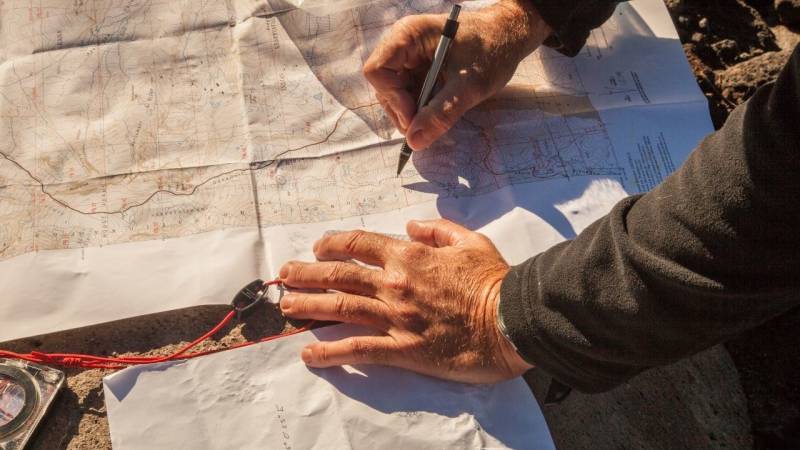
Map reading is a crucial skill in the world of survival, bushcraft, and outdoor activities. It involves the ability to interpret and navigate using maps, compasses, and other navigational tools. Understanding topographic features, symbols, and scales on a map is essential for planning routes, avoiding hazards, and finding your way in unfamiliar terrain.
Map reading is especially important for hikers, campers, and wilderness enthusiasts, as it allows them to navigate safely and efficiently. By mastering this skill, you can confidently explore new areas, locate water sources, and find your way back to civilization if needed.
Examples
„I love going on wilderness adventures, and one of the most important skills I've learned is map reading. It's crucial to be able to navigate through unfamiliar terrain and find your way back to camp or civilization.“
„During a recent hiking trip, my friend and I got lost in the dense forest. Thankfully, I had my trusty map and compass with me, and my map reading skills came in handy. We were able to pinpoint our location and find the correct trail to get back on track.“
„When teaching survival skills to beginners, I always emphasize the importance of map reading. It's not just about knowing how to read the symbols and contours on a map, but also understanding how to use it in conjunction with a compass and landmarks to navigate effectively.“
„I remember a conversation I had with a fellow outdoor enthusiast about the benefits of map reading. He shared how it had saved him from getting lost in the mountains multiple times. He stressed that relying solely on GPS devices can be risky, as they can fail or run out of battery, but a map is always reliable if you know how to read it.“
„Map reading is not just a skill for wilderness adventures; it's also useful in everyday life. Whether you're exploring a new city or trying to find your way around a large park, being able to read a map can make your journey much smoother and more enjoyable.“
Origin
The word "map reading" originates from the combination of the words "map" and "reading". The term "map" comes from the Latin word "mappa", which means cloth or tablecloth. It was used to refer to a representation of the Earth's surface on a flat surface. The concept of reading maps has been around for centuries, with early civilizations creating maps to navigate and explore their surroundings.
Map reading as a skill has evolved over time, with advancements in cartography and technology. In ancient times, maps were often hand-drawn and lacked the level of detail and accuracy we have today. As civilizations expanded and explored new territories, the need for more accurate and detailed maps became evident.
During the Age of Exploration in the 15th and 16th centuries, map reading became crucial for navigators and explorers. They relied on maps to chart their course, navigate through unknown territories, and discover new lands. With the advent of printing technology, maps became more widely available and accessible to the general public.
In modern times, map reading has become an essential skill for outdoor enthusiasts, hikers, and adventurers. It involves interpreting and understanding the information presented on a map, such as symbols, contour lines, and scale. Map reading allows individuals to navigate through unfamiliar terrain, plan routes, and make informed decisions based on their surroundings.
With the rise of digital mapping technologies, map reading has also adapted to include the use of GPS devices and online mapping platforms. These tools provide real-time location tracking, route planning, and additional information that can enhance the map reading experience.
Overall, map reading has a rich history and continues to be a valuable skill for anyone venturing into the great outdoors.
Synonyms
Navigation, Orienteering, Map interpretation, Cartography, Map analysis, Map study, Map navigation, Map reading
Antonyms
Misreading, Misunderstanding, Misinterpretation, Confusion, Disorientation, Ignorance, Illiteracy, Unfamiliarity
Relatives
Compass, Orienteering, Navigation, Topography, GPS, Wayfinding, Land navigation, Cartography
Historical and cultural importance
Map reading is a crucial skill for anyone venturing into the wilderness. It has a long history of importance, dating back to ancient civilizations. The ability to read and interpret maps accurately has been essential for explorers, navigators, and military strategists throughout history.
In ancient times, maps were often hand-drawn and depicted the known world as understood by the people of that era. These early maps were not as accurate or detailed as modern maps, but they still served as valuable tools for navigation and exploration.
During the Age of Exploration in the 15th and 16th centuries, map reading became even more significant. Explorers like Christopher Columbus and Ferdinand Magellan relied heavily on maps to navigate uncharted territories and discover new lands. Without the ability to read maps, these explorers would have been lost at sea.
In more recent history, map reading played a crucial role in military operations during both World Wars. Soldiers needed to understand and interpret maps to plan and execute strategic movements on the battlefield. Map reading skills were taught extensively to military personnel to ensure they could navigate unfamiliar terrain and locate enemy positions.
Today, map reading remains an essential skill for outdoor enthusiasts, hikers, and survivalists. With the advent of modern technology, maps have become more accurate and accessible than ever before. However, the ability to read and interpret maps is still vital, as it allows individuals to navigate without relying solely on electronic devices that may fail or run out of battery.
Overall, map reading has a rich historical and cultural significance, as it has been instrumental in exploration, navigation, and military operations throughout the ages. Mastering this skill is essential for anyone seeking to explore the great outdoors and survive in the wilderness.
More information about the term map reading
Understanding Map Reading
Map reading is an essential skill for anyone venturing into the wilderness. It allows you to navigate through unfamiliar terrain, find your way back to camp, and discover hidden gems along the way. In this guide, I will walk you through the basics of map reading and provide you with the knowledge you need to confidently navigate using a map.
Choosing the Right Map
When it comes to map reading, choosing the right map is crucial. Topographic maps are the most common type of map used for outdoor navigation. They provide detailed information about the terrain, including elevation, contour lines, and landmarks. Look for maps that cover the specific area you'll be exploring and ensure they are up to date.
Understanding Map Symbols
Before you can effectively read a map, you need to understand the various symbols and markings used. These symbols represent different features such as rivers, roads, trails, and buildings. Familiarize yourself with the key or legend provided on the map, which will explain what each symbol represents. This will help you interpret the map accurately.
Orientation and Compass Use
Once you have your map, it's important to orient yourself correctly. Start by identifying prominent landmarks on the map and comparing them to the actual landscape. Use a compass to align the map with the surrounding terrain, ensuring that the north on the map corresponds to the north in the real world. This will help you maintain a consistent direction while navigating.
Understanding Contour Lines
Contour lines are an essential part of map reading, as they provide valuable information about the elevation and shape of the land. These lines connect points of equal elevation, allowing you to visualize the terrain's steepness and identify features such as hills, valleys, and ridges. Pay close attention to the contour intervals, which indicate the vertical distance between each line.
Using Grid References
Grid references are a system used to pinpoint specific locations on a map. They consist of a combination of letters and numbers that correspond to specific grid squares on the map. By using grid references, you can accurately communicate your location to others and navigate to specific points of interest.
Practice and Experience
Map reading is a skill that improves with practice and experience. Start by using maps in familiar areas and gradually progress to more challenging terrain. Take the time to study your maps before heading out and regularly check your progress along the way. With time, you'll become more confident in your ability to navigate using a map.
Remember, map reading is a valuable skill that can enhance your outdoor experiences and keep you safe. By understanding the basics of map reading, you'll be able to explore new areas with confidence and discover the wonders of the wilderness.
Back to overview